

In this series of articles, Utah artist J. Brad Holt talks about what artists are seeing as they look at the landscape. Holt studied geology in college and is attentive to what the rocks suggest in the scenes he paints.
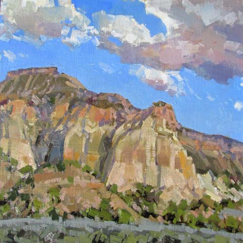
The painting above shows a view into the amphitheater of Cedar Breaks National Monument. Cedar Breaks lies about 20 miles east of where I live, high on the western summit of the Markagunt Plateau at about 10,000 feet. The colorful spires and hoodoos of Cedar Breaks and nearby Bryce Canyon are composed of Miocene Age lake-deposited limestone of the Wasatch or Claron Formation. How did these beautiful places come to exist? What is responsible for the myriad shapes of the landforms around us?
The branch of earth science that attempts to answer these kinds of questions is called geomorphology. I recall that my undergraduate geomorphology textbook was subtitled A Study of Late Cenozoic Landforms. I supposed that there were several reasons for this. We must acknowledge that the present moment is also the end of the Cenozoic Era, but beyond that, we must admit that our knowledge of pre-Cenozoic landscapes is largely conjectural, based on deductions drawn from limited fossilized landforms, such as the cross-bedded sandstones of nearby Zion National Park, which tell us that sand dunes during the age of the dinosaurs were not significantly different from sand dunes in the world of the present day. For the most part, our view of ancient landforms is something of a matter of faith in the concept of uniformitarianism, which holds that the world has been shaped by the forces and processes that we observe around us today.

I think another reason for that subtitle is the fact that for most of the landscape visible on the surface of the earth today, we are closely studying the recent past — largely, the last couple of million years of earth’s history. Although the rock layers that are being acted upon are significantly older than that, the events that put them into their present disposition have largely taken place since the Miocene Epoch, since the time when Cedar Breaks was laid down. We would not recognize the landscape prior to this time, though we would recognize the principles and processes.
Geomorphologists look at the landscape much as a detective might view a crime scene: attempting to deduce, from the evidence present, a logical history that would explain it. There are many factors that must be considered when attempting to understand the appearance of landscapes. First, there is the actual composition, properties, and positioning of the rock layers involved. What are the rock types? How were they emplaced? How have they been uplifted? How much stress have they undergone?
These questions are concerned with tectonic and orogenic themes, for the most part. Much of this emplacement occurred before the mid-Tertiary period, setting the stage, as it were, for today’s landscape. Specifically, we are looking at faulting and folding, uplift and over-thrust, igneous intrusions and extrusions, rifting, compression, and geosynclinal deposition. By the end of the Miocene Epoch, roughly 5 million years ago, the continents were close to their present positions, coastlines were somewhat recognizable, and most of the major mountain ranges were in place, or well on their way.
The second major factor to consider with regard to landforms is climate, including prehistoric climates. Annual precipitation, severity and frequency of storms, and the presence of ice have a great influence on the sculpting of a landscape. Climate factors change through time. Many regions that are temperate today were shaped largely through glaciation during the Pleistocene Epoch. Changes include sea-level fluctuations and precipitation patterns. In North America, glaciation is responsible for many well-known landforms. Ice sheets carved the lobed forms of the Great Lakes. The hooked form of Cape Cod, though it superficially resembles smaller sand-spits formed by currents and waves, is actually a terminal glacial moraine, as are the islands of Nantucket, Martha’s Vineyard, and Long Island. New England and the Upper Midwest are full of glacial erratics, drumlins, eskers, and moraines. In my area, the Great Basin was a region of vast freshwater lakes during the Ice Age. The ancient shorelines of Lake Bonneville are still very visible on the hills around Salt Lake City. Much of the landscape visible today took on its present form during this period.
Other factors to consider are elevation, volcanism, sea level, vegetation, and cataclysm. Rock layers will tend to erode differently in different climates and elevations. More storms at higher elevations mean more weathering, as do greater amounts of freezing and thawing. I have noticed that certain sandstone formations take on a more rounded, sculpted form at 8,000 feet than they do 40 miles away at 5,000 feet. Some of this may be due to facies variation — most sedimentary rock formations display changes in thickness and composition as they are tracked laterally; this is called facies variation — but more moisture, and frost spalling, are undoubtedly a factor. In arid or semi-arid country, lack of year-round streams means that most of the products of erosion, weathering, and mass wasting are seldom carried far from their point of origin. The result of this is that eventually, points of elevation will tend to become buried in their own alluvium, leaving just small erosional remnants, or inselbergs, surrounded by broad alluvial fans.
Volcanism influences the landscape in several ways. Intrusive emplacement causes uplift and stress or deformation of present rock layers. Extrusion may create new landforms such as cinder cones, strato-volcanos, or calderas to form. Outflows of large amounts of basalt or rhyolite can cover existing topography, creating new landforms and influencing the erosion of existing forms. An example of this occurred in the area just south of me, near St. George, Utah. Ancient lava flows covered some valley floors, then subsequent erosion occurred around these flows, which have now become the caps of mesas. These are called inverted valleys. In some areas, such as in Iceland and Hawaii, volcanism is responsible for creating all of the land. Indirectly, volcanism influences climate through the introduction of large volumes of sulfur dioxide and fine ash into the atmosphere.
The influences of coastal erosion and the modifying influence of vegetation are largely self-evident. Just as on land, the greatest sculpting of rock occurs during storms. This is also certainly the case with cataclysm, which, though infrequent, adds up across geological time, leaving a major stamp upon the features of the land.
Cataclysms may strike from many sources. Extraterrestrial debris has rained down upon the earth throughout geological history; in fact, earth scientists attribute the accumulation and formation of the planet to such an origin. The asteroid impact at the close of the Cretaceous Period, which most paleontologists credit with the demise of the dinosaurs, undoubtedly caused massive changes in climate and landscapes. Earthquakes and resulting tsunamis sculpt coastal regions, while vast floods from the breaching of Ice Age lakes have carved large regions of the American West. By such moments of tumult and violence, and through long periods of gradual change, and the turn of the seasons, the landscape that we know has taken its present form. When we paint this landscape, we are painting the history of our world.


