

In this series, Utah artist J. Brad Holt talks about what artists are seeing as they look at the landscape. Holt studied geology in college and is attentive to what the rocks suggest in the scenes he paints.
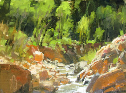
Lead Image: “Irrigation Ditch Overflow, Cedar Canyon,” by J. Brad Holt, 2014, oil, 12 x 12 in.
The water that we see in lakes and rivers accounts for less than a hundredth of a percent of the total water in Earth’s hydrosphere. More than 97 percent is in the oceans. Most of the remnant is locked in glaciers and icecaps. The tiny bit that we see is insignificant compared with the vast amount we don’t see, which is moving beneath our feet as groundwater. And yet the movement of water through the hydrological cycle, fractional though it may be, is responsible for carving our landscape, and sustaining our lives. The stages of the hydrological cycle are evaporation, evapotranspiration, precipitation, runoff, and infiltration. It is estimated that in North America at any given time there is six times more water being carried aloft in the form of vapor than is being transported by rivers and streams.
When we see a broad river flowing, we tend to think that it is simply the result of precipitation somewhere upstream, and in a roundabout fashion, this is true. But what we do not see is the overall movement of groundwater, which feeds and sustains the river from thousands of points along its course. If not for this underground water, most rivers would soak into the ground and be lost within a few miles. This actually happens to some rivers in arid regions, at least in those portions of the course that are not contained within bedrock.
The land that is drained by a particular river is called a drainage basin. These basins are hierarchical, where one basin might be part of a larger basin. For example, the Yellowstone River basin is part of the Missouri River basin, which is part of the Mississippi River basin. A divide is an imaginary line that marks the boundary between basins. Usually a divide will be along a mountain ridge, but sometimes it will just be a slight elevation. For instance, just south of where I live, near the town of Kanarraville, Utah, there is a divide between the Great Basin and the Colorado River drainage basin. This divide is only a slight rise in elevation, through a broad valley.
River systems consist of three main zones: a zone of erosion, a zone of sediment transport, and a zone of sediment deposition. In most rivers this equates to the headwaters, the trunk of the stream, and the stream mouth. However, these processes are occurring simultaneously to some extent all along the stream. We are simply recognizing which process is most dominant in each part of the drainage. The flow of water in a river may be laminar or turbulent. Laminar flow occurs in slow-moving streams, with water flowing straight along the channel. Turbulent flow is more common, with the water flowing in a swirling fashion.
The velocity of a stream is determined by the gradient, channel characteristics, and discharge. Gradient changes over distance; most streams have a steep gradient near the headwaters that gradually diminishes downstream. If we were to make a graphic chart of a stream’s gradient change from the headwaters to the mouth, we would call it the stream profile.
Discharge is the volume of water flowing past a fixed point in a fixed unit of time, usually given as cubic feet per second. Discharge changes with the season, and even with day-to-day weather. Spring snowmelt and storm runoff can change discharge levels by enormous amounts. In arid regions, dry hot weather can diminish flows, creating intermittent streams. Channels that flow only with storm runoff are called ephemeral streams.
In most river systems, the highest gradient and the zone of erosion are near the headwaters, because most streams originate in areas of higher topographic relief. Higher gradients contribute to higher velocities, while lesser discharge and rougher channels slow velocities. Thus most of the real work of erosion occurs during floods, either from spring runoff or from storms.
Transportation of sediment material occurs in all streams. There are three types of transport: dissolved load, suspended load, and bed load. Dissolved load is generally introduced through groundwater. Dissolved carbonates are common in limestone regions. Other dissolved minerals may include iron, magnesium, salts, and some silica. Changes in velocity will not affect dissolved load.
Suspended load consists of fine particles that impart a visible color to the water. This is the bulk of transported material. Velocity and discharge are the controlling factors on the amount of suspended load. As velocities decrease, loads in suspension tend to settle out. In many streams, this occurs differently in different parts of the channel. Higher velocities on outside bends may carry more in suspension than inside bends, where flow rates slow down. Thus, sandbars tend to form on inside bends.
Bed load is that portion of sediments too large to be carried in suspension, but small enough to be tumbled along the streambed, in those areas of maximum velocity. Most bed load stays put on normal days, but it can move great distances during floods. The maximum size of particles a stream can carry is called the stream competence, while the stream capacity is a measure of the maximum amount of load it can move.
When stream velocity slows, the stream loses competence, and load settles out. This deposited load, sorted by gradations of velocity, is called alluvium. Stream channels are basically divided into bedrock channels and alluvial channels. Bedrock channels are where a stream is actively carving a channel through exposed rock. Usually this occurs high on the front end of the stream profile. Such channels often have rapids and waterfalls. Wherever gradients decrease, the stream will tend to accumulate an alluvial channel.
In regions of low topography, most alluvial channels will begin to move in sweeping bends called meanders. Meandering streams erode gently on the outside of the bends, or the cutbank, and deposit fine material on the inside bend, or point bar. They also erode more on the downstream bank; thus, meanders will tend to move incrementally downstream. Where the volume of alluvium is great, and coarse, and the volume of discharge varies widely over short amounts of time, a braided channel may develop. Braided channels are common where flooding and great amounts of erosion are taking place.
Stream valleys may be V-shaped near the headwaters, where active erosion is occurring. Further downstream, the valley may widen to the width of the meanders of the stream. Eventually a broad floodplain will develop. Any changes to the stream’s gradient profile will result in newer, lower floodplains developing, with the old floodplain edges remaining as terraces. Occasionally mature streams with full meanders are rejuvenated by regional uplifting, which lowers the end of the stream profile and causes the stream to begin down cutting again. This results in incised meanders, which are an admired feature common in the Colorado plateau region.
Other depositional features include deltas and alluvial fans. Deltas form at the end of a stream where it flows into a broad body of water. As stream flow slows, remaining suspended load is released and deposited, building a fan-shaped deposit out into the water. The stream may divide into distributary channels, further accentuating the fan shape of the delta. In arid regions where intermittent or ephemeral streams carry vast loads of coarse alluvium only during infrequent flash floods, broad alluvial fans develop around all points of elevation. These alluvial fans will deepen and overlap sometimes, until only a few nubs of the original mountains remain exposed. These are called inselburgs. This sort of topography is common in the basin and range region.


