

In this series of articles, Utah artist J. Brad Holt talks about what artists are seeing as they look at the landscape. Holt studied geology in college and is attentive to what the rocks suggest in the scenes he paints.
I live on the border between two major physiographic provinces of North America. To the east of me is a broad region of high plateaus, mesas, and canyons known as the Colorado Plateau. It is a land of color and beauty, as the eight national parks, dozens of monuments, and hundreds of state parks there will attest. Geologically, it is primarily made up of a thick veneer of sedimentary strata from the Mid-Paleozoic era forward.
Scattered throughout the region are areas of both intrusive and extrusive igneous rock. To the west of me is the Great Basin, and the Basin and Range Province, which mostly overlap. The Great Basin is a region of the interior West that has no outlet to the sea. All of the water in this vast area comprising all of Nevada, Western Utah, Eastern California, and parts of Oregon flows into broad, salty playas, and is lost to evaporation, or sinks as groundwater.
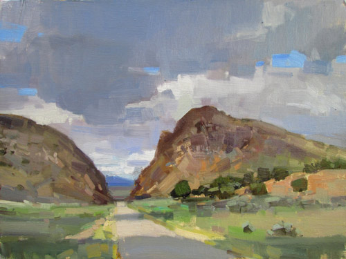
“Parowan Gap,” by J. Brad Holt, 2014, oil, 12 x 16 in.
The Basin and Range Province consists of a large region of block-faulted, north-south-trending mountain ranges. The area is fairly arid, owing to a rain-shadow cast over the region by the Sierra Nevada Mountains in California. Most of this land is wild, rugged, and beautiful, with perhaps a more subtle and refined beauty than that of the Colorado Plateau.
The topography of this region can be staggering. Barely a hundred miles separates the highest point in the contiguous states, at Mt. Whitney, from the lowest point, in Death Valley. During the cooler, wetter time of the last Ice Age, there were numerous lakes in the valleys between ranges, including the massive Lake Bonneville, in the northeast, and Lake Lahontan, in the northwest areas of the province.
When Lake Bonneville found an outlet at Red Rock pass in Southeastern Idaho, it partially drained in a great flood that carved the deep canyons of the Snake River. The Great Basin is an amazing land of high mountain peaks, clad in aspen and spruce, interspersed with forbidding salt pans, miles of sagebrush, and great piñon-juniper forests. At the south end, a few high ranges in Utah, Nevada, and California host the last stands of bristlecone pines, the oldest living organisms on earth.
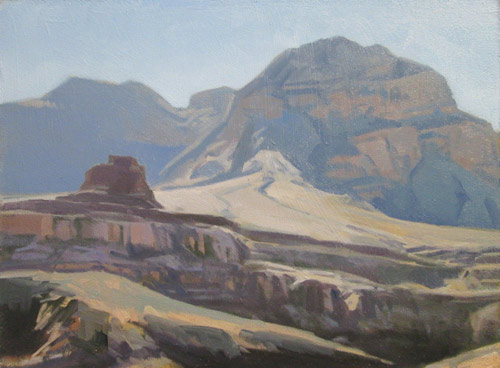
“Virgin River Gorge Series II,” by J. Brad Holt, 2014, oil, 9 x 12 in.
So how did the Basin and Range Province form? The short answer is tectonic forces at the western edge of the North American plate. We don’t completely understand all the mechanisms involved, but we can make some educated guesses. About 40 million years ago, the West Coast was approximately along the eastern edge of the San Joaquin Valley. The Great Basin was a region of active volcanism, somewhat like the Pacific Northwest is today. The East Pacific rise was just off the West Coast, soon to be subducted. As island arcs and continental fragments plowed into the western edge of North America, they accreted to the plate, becoming the terranes that comprise the western half of California, Oregon, and Washington.
This caused great compression, which seems to have lifted the Great Basin in a vast arch. After the spreading center of the East Pacific rise subducted, this pressure ceased, and was replaced by the northwest-trending pressure from the west side of the rise. Now a tensional force began to pull the Great Basin apart, resulting in the numerous block-faulted mountain ranges. Downfaulted blocks between ranges became long valleys, slowly filling with alluvium. The continental crust is thinner under the Great Basin than it is in the rest of North America.
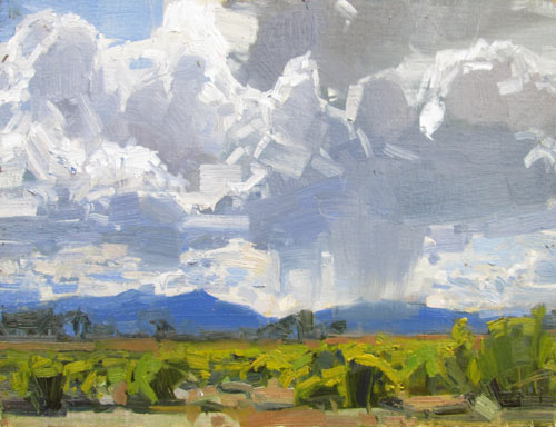
“Cloud Study, Cedar Valley,” by J. Brad Holt, 2014, oil, 9 x 12 in.
The spreading center of the East Pacific rise is present in the Gulf of California. It separates Baja California from the rest of Mexico. It is surmised that the remnants of it continue north beneath the state of Nevada. The extent to which it is still active, and contributing to the rifting of the Great Basin, is not known. It is interesting to think that in a few millennia, I might have beachfront property here in Southern Utah! (I’m not holding my breath.)
What is generally agreed on is that Baja, and the West Coast, will continue to move north, along the San Andreas transform fault, until eventually it plows into the south coast of Alaska. It will certainly be too light to subduct, and will accrete there as a new terrane.
So what physiographic province do you live in? Do you know its geological history? Every region on earth has wonderful stories to unfold to those who have the curiosity to listen. Places that may seem sleepy now were once the arena of tectonic tumult. Was your area ever part of Pangaea? Were there oceans, swamps, deserts, or big mountains there? What amazing species of extinct life are found near you? Did glaciation play a role in shaping the landforms around you? Support your local geology, learn the secrets it has to tell, and prepare to be astonished.


